


Nakuru County has witnessed a worrying rise in sinkholes and ground fissures over the past three years, underscoring the geological instability of the Rift Valley, one of the most tectonically active regions in the country.
Geologists say the phenomenon is often triggered by heavy rainfall, which exposes fault lines buried deep beneath the surface. With the current rainy seasons, what once brought relief to residents now brings fear, as the ground beneath homes, farms and roads shows signs of giving way.
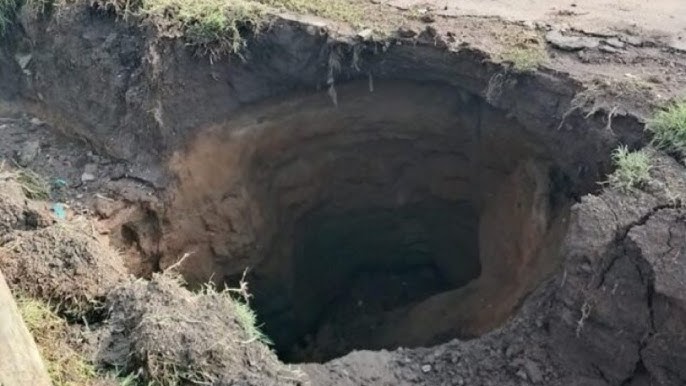
For residents like Mercy Nyaboke and Sheila Bukachi of Kaptembwa, every downpour revives memories of May 9, 2024, when a massive sinkhole opened up, displacing more than 500 families and destroying dozens of homes. One year later, some houses remain unsafe, while others have been temporarily repaired.
“Mvua ikinyesha nyinyi huwa tunatoka nje tuone kama tutabebwa au hatutabebwa,” said Ms Nyaboke.
“Inaweza poromoka na hatuna habari…tuko na uwoga kwa sababu shimo bado iko ukienda hiyo upande,” added Ms Bukachi.
Across the county, fissures have cut through agricultural land, residential estates and key transport corridors. On September 4, 2025, a sinkhole opened along the Nakuru Eldoret highway at the Eveready area. A similar incident had occurred at the exact location on the same date in 2024, raising alarm over recurring ground instability.
“Tunakaa na uwoga kama vile iliteremsha manyumba huko chini inahitaji suluhisho,” said Martin Obongi, a resident of Kapkures.
Geologists have since mapped some of the most vulnerable areas. Investigations have identified an active fault line, known as the Makalia fault, stretching from the Menengai crater through to Lake Nakuru. Areas along this fault line include Kaptembwa in western Nakuru, Gioto to the northeast, Eveready and Kiamunyi in the north west, where sinkholes have repeatedly appeared.
Further studies are ongoing in Ngata, southwest of Nakuru city, and in Gilgil to the northeast.
“That is only one but some of them are not visible because of the layer. We have done some mapping and we shall be able to identify them. We are still continuing with the studies to map all of them so that we can warn the public not to construct along the area,” said John Lagat, a geologist at the Geothermal Development Company.
County officials warn that several rivers also pose a risk.
“All the estates, Kaptembwa through the Shabaab area that separates Rift Valley Institute. We have a bigger one in the area of the Bagaria River. The Bagaria River and Njoro River are potential sinking areas,” said Kamau Kuria, the County Executive Committee member for housing and urban development.
The growing number of sinkholes has fuelled public speculation that the Rift Valley could be splitting apart, potentially leading to the formation of a new lake. Experts, however, caution against alarmist conclusions.
“People are associating it with the rifting, and there are reports that there will be a lake soon. The rate it is opening up is one cm or two cm per year. It will take hundreds of years for that to happen,” Mr Lagat explained.
Nakuru is among Kenya’s fastest growing urban centres, with new estates and high rise buildings rapidly transforming its skyline. Scientists warn that this growth must be matched with rigorous geological assessments.
“A number of buildings have cracks, we do not have a rock basement. Menengai, Longonot, Eburru is dormant. How sure are we of dormancy that may not trigger a vent that will make them erupt,” said Clement Lenashuru, a natural resource scientist.
County authorities say a comprehensive resilience plan is already underway. By February next year, Nakuru, Naivasha and Gilgil are expected to adopt a unified framework to guide urban growth and reduce disaster risk.
“There are areas we are limiting the approvals and that is the western side along the fault line, River Njoro, Bagaria fault line and this other area in consultation with NEMA, and we will peg these areas to ensure there is no actual development,” Mr Kuria said.
As studies continue, urban planners insist that approvals for multi storey buildings must only be issued after detailed geotechnical surveys, a measure they say is critical to keeping residents safe in a region where the earth itself remains in motion.


